The Whole Earth: how a geographical society appeared in Russia

On August 18, 1845, Emperor Nicholas I approved the proposal of the Minister of Internal Affairs Lev Perovsky on the establishment of the Russian Geographical Society. Today it is the oldest active public organization in our country. Izvestia recalled the history of the creation of the Russian Geographical Society.
Society should be
By that time, Russia had already made a significant contribution to the annals of geographical discoveries and research. At the initiative of Peter the Great, the First Kamchatka expedition was equipped under the leadership of Vitus Bering and Alexei Chirikov. The heirs of the first emperor organized the Second Kamchatka Expedition, which brought dozens of important discoveries in the North Pacific Ocean. These were the world's largest government-supported scientific expeditions. In the first quarter of the 19th century, Russian sailors and researchers organized several trips around the world. And the crowning achievement of this activity was the expedition of Thaddeus Bellingshausen and Mikhail Lazarev (1819-1821), which resulted in the discovery of Antarctica.

"Antarctic Icebergs" is a reproduction of a drawing from nature by artist P. Mikhailov, a participant in the first Antarctic expedition on the Vostok and Mirny boats led by Thaddeus Bellingshausen and Mikhail Lazarev.
In the early 1840s, geographical societies already existed in several European countries - in Prussia, England, and France. Since 1843, a circle of statisticians and travelers has been working in St. Petersburg on a private basis. He became the foundation of the future society. Emperor Nicholas I, who possessed an engineering mind and was fond of military topography, approved the idea.

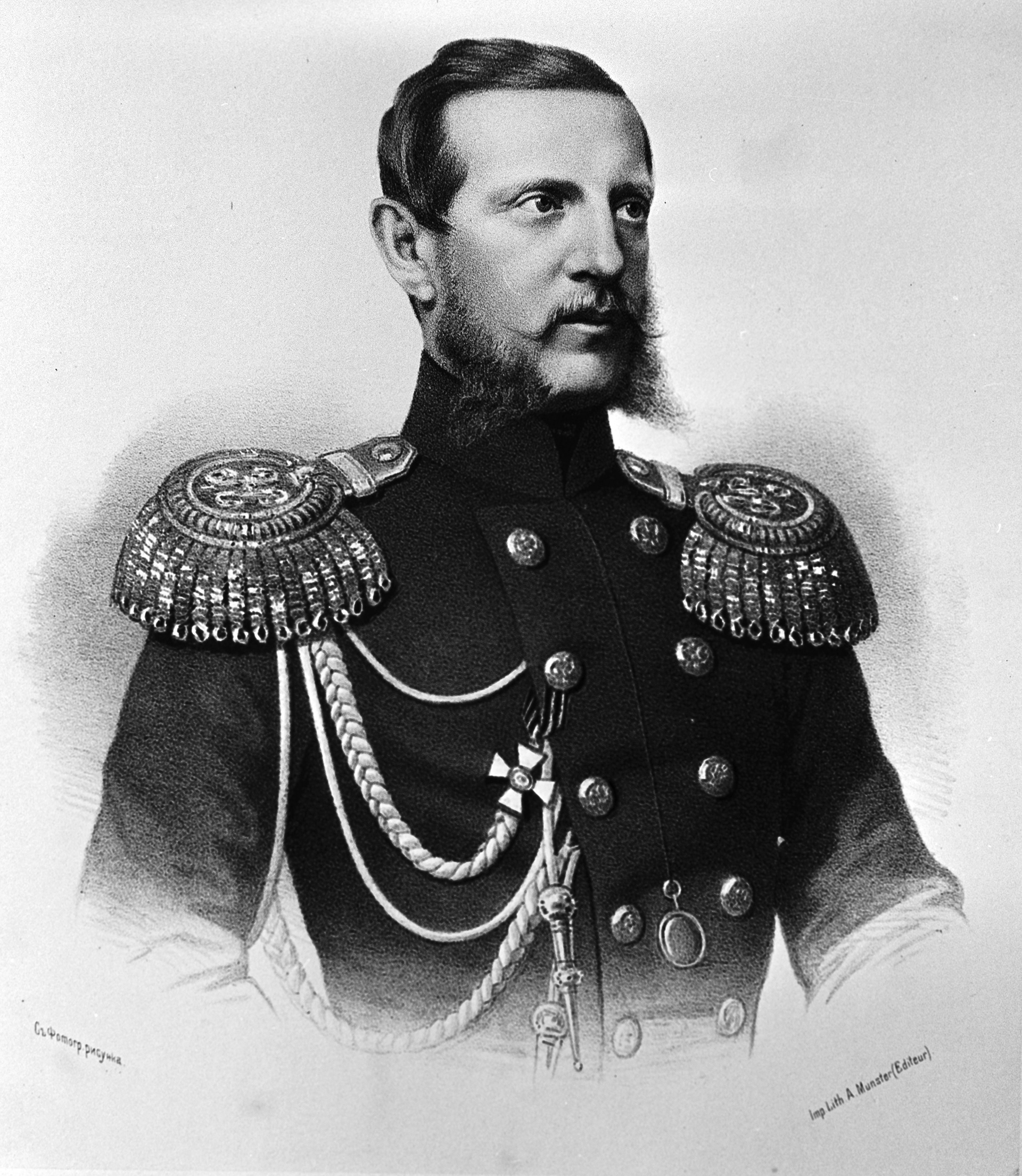
The first chairman of the Russian Geographical and Statistical Society (as it was called at first) was Grand Duke Konstantin Nikolaevich, the patron saint of the fleet and a student of Admiral Fyodor Litke, who is rightfully considered the initiator of the creation of the "noble assembly of travelers." Litke prepared a draft charter, which was signed by the founding members. "The knowledge of the Russian state," these words, written above the first charter of the society, became its motto. And among the founders of the society were Ivan Kruzenshtern, Ferdinand Wrangel, Vladimir Dahl, Mikhail Muravyov — extraordinary and bright people who have done a lot for Russian science.
In October 1845, the first general meeting of the full members of the Russian Geographical Society was held in the conference hall of the Imperial Academy of Sciences and Arts, which elected the society's council. The founders of the Russian Geographical Society set themselves the goal of "cultivating geography." And by and large— to study the Fatherland. Russia is so huge that its spaces need to be explored for centuries. Russian Russian Society was conceived as "a free and open corporation for all who are imbued with love for their native land and a deep, unshakeable faith in the future of the Russian state and the Russian people."
A year later, the Grand Duke established the main award of the society — the Constantine Medal. Then others were added to it... And in 1850, the society received the status of an Imperial one. Geographical research was patronized by the monarchs. The society also received financial support from patrons, especially from Siberian merchants.
A series of discoveries
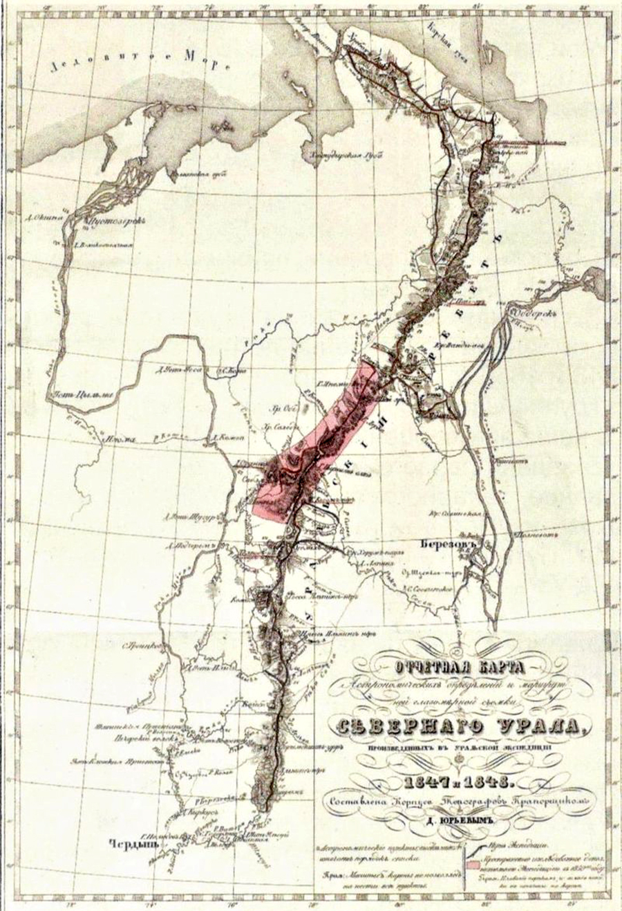
The first expedition of the society, led by Professor Ernst Hoffmann, studied the Northern Polar Urals from the sources of Pechora to the Arctic Ocean. One of the main areas of the geographical society's work has become the study of the Arctic and the Far North. All significant Russian polar research was carried out with the information, financial and technical support of the society.
The scientific expeditions of the Russian Geographical Society have played a major role in the exploration and development of Siberia, the Far East, Central and Central Asia. Formally, the society's activities were limited to the borders of the Russian Empire and neighboring Asian states. But the envoys of the Russian Geographical Society explored all parts of the world over the years.

Portrait of Pyotr Semenov at the exhibition "The Artistic Heritage of the Semenovs-Tyan-Shansky" in the Blue Hall of the Scientific Research Museum at the Russian Academy of Arts in St. Petersburg
For about two years, in 1856-1857, the Tien Shan expedition of Peter Semenov continued. The traveler drew up the first diagram of the orography of the Tien Shan in the form of a system of ridges, obtained data on the geological structure of the country, and collected a collection of rocks. He found that there are no volcanoes and volcanic rocks on the Tien Shan. Since 1873, for more than forty years, Semenov has actually been at the head of the geographical society, with the status of vice—chairman. On his initiative, the first large-scale population census was conducted in Russia in 1897.
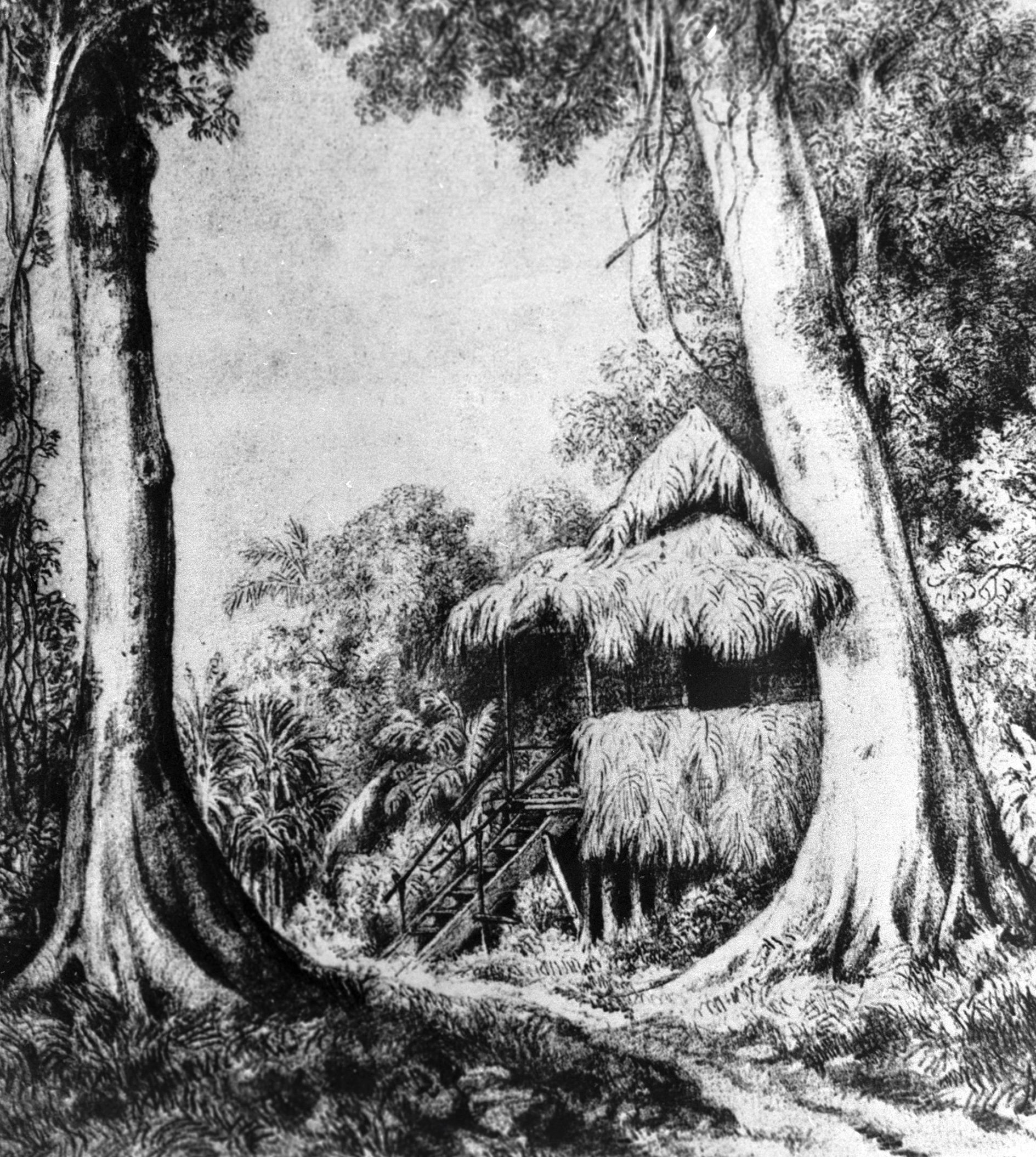
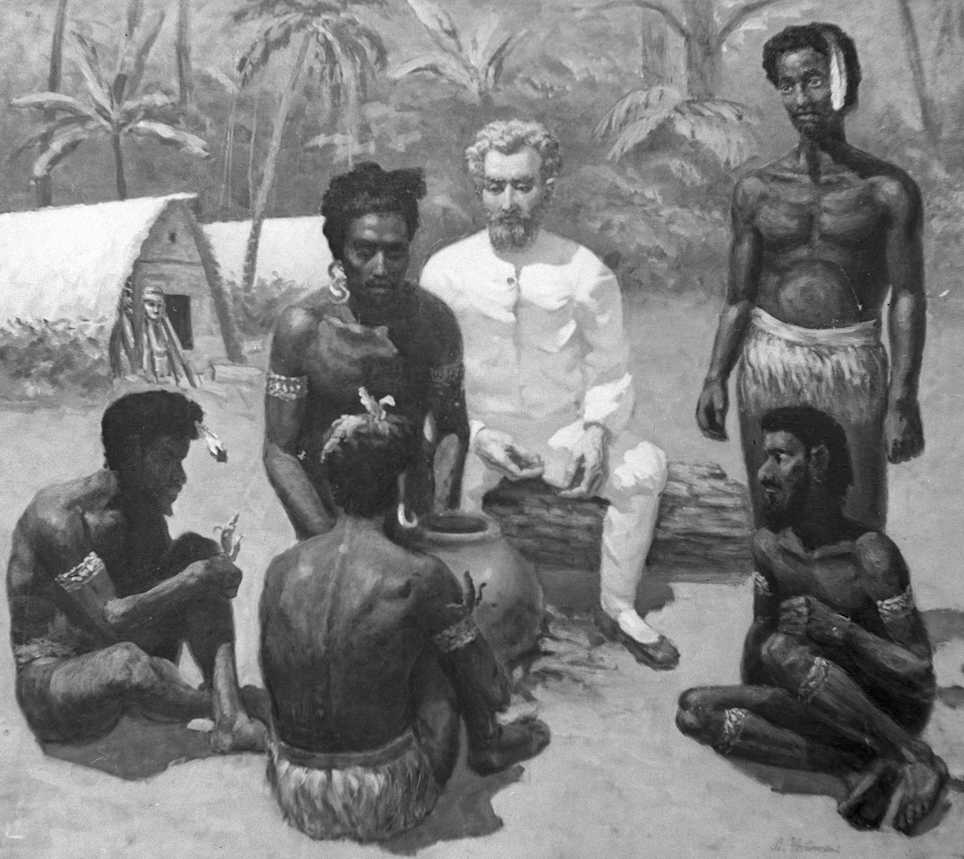
Nikolai Miklukho-Maklay became a true pioneer for world ethnography. In 1869, he submitted to the Council of the Geographical Society a draft expedition to the Pacific Islands for zoological and anthropological research. Thanks to the support of the Russian Geographical Society, the great traveler sailed on the corvette Vityaz to the shores of New Guinea, where he spent 15 months. After returning from a trip, Miklukho-Maklay presented the archive of the society with a part of the ethnographic collection he had collected. Miklukho-Maklay published dozens of scientific papers that formed an epoch in science in the "Proceedings of the Imperial Russian Geographical Society".
The name of the great traveler is one of the most honorable awards of the society — the Gold Medal, which is awarded for achievements in the field of anthropology and ethnography.
An entire epoch in the history of geographical discoveries was made by Nikolai Przhevalsky, a born traveler who discovered the Ussuri region, Mongolia and Tibet for science. "The vastness in the desert is what I dream about day and night. Give me mountains of gold, I won't sell my wild freedom for them," was his principle. The traveler, who infected students and high school students with his thirst for discovery, created the first accurate maps of Central Asia, discovered the "moving" Lake Lobnor, and collected unique collections...

Monument to the traveler and naturalist Nikolai Przhevalsky
In 1889, archaeologist and journalist Nikolai Yadrintsev, with the help of the East Siberian Branch of the Russian Geographical Society, organized an expedition to the upper reaches of the Orkhon River, collected a rare collection of minerals and herbariums. He managed to find the ruins of medieval Karakorum, the ancient capital of the Mongol Empire.

The ruins of Hara Hoto in the 2016 photo
The oldest paper money on earth, printed during the Yuan Dynasty, was found in the Gobi Desert by Peter Kozlov, an outstanding archaeologist and ethnographer who studied Mongolia and Tibet. He discovered the "Asian Pompeii" — the city of Hara Hoto, lost in the sands. In addition to the "banknotes," he discovered thousands of manuscripts among the ruins.
The place of action is a planet
After the death of Konstantin Nikolaevich, the society was headed by Grand Duke Nikolai Mikhailovich, and starting in 1917, the chairmen (later presidents) began to be elected. The famous hydrographer Yuli Shokalsky became the first chairman of the Soviet-era society. He bequeathed to the Russian Geographical Society his library, which consisted of 13 thousand books and magazines and 4 thousand maps. In 1918, the world's first higher educational institution of a geographical profile, the Geographical Institute, was launched. In Petrograd, on the Moika embankment. Now it is the Institute of Earth Sciences of St. Petersburg State University. In 1938, through the efforts of the society's leaders, a Central Lecture Hall was opened in Leningrad, at the opening of which Shokalsky read a report on the travels of Nikolai Przhevalsky. Since then, the voices of Thor Heyerdahl, Yuri Senkevich, Lev Gumilev have been heard in the lecture hall... And nowadays the lecture hall has a rich program, its doors are open to all concerned. Since 2011, the RGS lecture hall has been operating in Moscow.

Biologist and traveler Nikolai Vavilov
After the death of Academician Shokalsky, he headed the society for almost a decade (with the status of president!) the famous biologist and traveler Nikolai Vavilov. In the 1970s, a new boom in travel and geographical exploration began in the Soviet Union. From the Arctic to Antarctica. The Planeta Student Club was established at the society, which was attended by schoolchildren, undergraduates and graduate students. Enthusiastic young people, seasoned hikers, researchers, future geographers, topographers, meteorologists... Today, many of them have become scientists and pioneers. Knowledge and traditions are passed down the chain from generation to generation.
Today and tomorrow
The largest geographical library in Europe, with about 500,000 volumes, operates at the headquarters of the Russian Geographical Society. The first Russian relief globe is also kept there. Today, anyone can get acquainted with the holy of holies of the Russian Geographical Society: guided tours are held at the headquarters. The modern geographical society is actively and fruitfully engaged in education. What the Arctic Floating University is worth is a wonderful project, both research and educational.
Since 2009, the Russian Geographical Society has been headed by Sergei Shoigu. Since that time, the company's activities have expanded significantly. The nature of Russia is diverse and mysterious. Its protection is the most important task of the geographical society nowadays. The most famous projects of the Russian Geographical Society are the Amur Tiger, the Far Eastern Leopard, and the Polar Bear. Every year since 2001, the Barneo camp, a scientific center for the study of the Arctic, has been built on the drifting ice of the Arctic Ocean in the area of 89 ° north latitude.

Since 2021, a comprehensive expedition of the Russian Geographical Society has been operating on Franz Josef Land, conducting research on hydrology, permafrost and biology of the Arctic islands. An equipped scientific laboratory of the Russian Geographical Society operates in the archipelago all year round.

The Russian Geographical Society's round-the-world expedition dedicated to the anniversary of the society and the 200th anniversary of diplomatic relations between Russia and Brazil continues. An ice-class yacht is moving along the Northern Sea Route, filming a film about the journey. This is both a research project and an example of public diplomacy. The expedition will end in Brazil in 2026.

The Fraternidade yacht with the Russian-Brazilian crew of the International circumnavigation of the World sailing expedition "Brotherhood-2025" leaves the parking lot near the nuclear icebreaker "Lenin" in order to proceed along the Northern Sea Route. Murmansk, July 15, 2025
In 2020, the Russian government officially established a professional holiday — Geographer's Day. For five years we have become accustomed to this solemn date, which is rightfully celebrated on the day of the founding of the Russian Geographical Society.

Cadets are participants in a long-term integrated expedition of the Russian Geographical Society to the islands of the Kuril Ridge during geodetic measurements on the island of Simushir
Today, RGS branches operate in all regions of Russia. It only seems that every square meter on our planet has been explored today. The emergence of new technology helps researchers, but it does not solve all problems like a magic wand. Talent, professionalism and courage are still essential. Travelers, ethnographers, and ecologists of the future today go to the lecture halls of the Geographical Society and join the youth clubs of the Russian Geographical Society... The future belongs to them. The society, which turns 180 years old, is young again and aspires to the future.
The author is the deputy editor—in-chief of the magazine "Historian"
Переведено сервисом «Яндекс Переводчик»
